The 17 Provinces


The marriage contract (April 25, 1369) for the daughter Margaret of the Flemish duke Louis of Male with Philip of Burgundy, brother of the King of France Charles V formed the core of the gradual formation of the United Netherlands (territorial wise, at the end of the process, largely coincident with the actual Benelux countries; were not included though: the principality of Liège, the principality of Stavelot, the duchy of Bouillon and several smaller territories and enclaves)

The contract brought  initially under one single lordship:
-    the county of Flanders
-    Lille-Douai Orchies (once belonging of the count of Flanders, lost to France in 1305)
-    Artois (once belonging of the count of Flanders, lost to France in 1212)
-    the duchy of Burgundy
-    the county of Burgundy (Franche Comté)
(The first four territories were legally fiefs of France; the fifth was legally a fief of the Holy Roman Empire, or Germany)

Later the Dukes of Burgundy, followed by their Habsburgian successors, expanded gradually these territories, and got feudal ties to France suspended.

The territories in the North initially got “les pays de par deçà” (in Dutch of the time: “de landen van herrewaarts over”) as common name, opposed to the “pays de Bourgogne”, later it became the “pays d’embas” for the North and finally the “pays bas” (Netherlands).

The different territories, getting some form of common government and common institutions, could protect though and maintain largely their own institutions and law, so we quite often see them listed separately rather than under common name. One of the confusing common names in the mid of the 16th century was “the 17 provinces”, but the lists of these 17 territories were not always mutually consistent.

17_pro.jpg
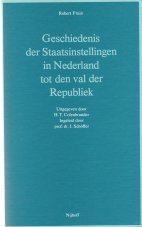
The text below (in Dutch) is quoted (p. 25-26) from: Robert Fruin, Geschiedenis der Staatsinstellingen in Nederland tot den val der Republiek, (1901) tweede bijgewerkten druk, 1922 (reprint 1980, 's Gravenhage, Martinus Nijhoff, isbn 90-247-9022-0, xxviii + 436 pp.)
Fruin lists:
- the territories listed when defining the Burgundian Kreits as part of the German Empire
- the territories represented in the Staten-Generaal (a kind of a common Senat), considred to form the 17 provinces

Gaan wij de landschappen na die in den Bourgondischen kreits vereenigd werden, dan vinden wij er Nederlandsche onder en niet-Nederlandsche.

Genoemd worden
  • de hertogdommen
    • Lothrijk,
    • Brabant,
    • Limburg,
    • Luxemburg,
    • Gelder;
  • de graafschappen
    • Vlaanderen,
    • Artois,
    • Bourgondië (Franche Comté),
    • Henegouwen,
    • Holland,
    • Zeeland,
    • Namen,
    • Zutfen
    • en Charolais;
  • het markgraafschap van Antwerpen of van het Heilige Roomsche Rijk-,
  • de heerlijkheden
    • Friesland,
    • Utrecht,
    • Overijsel,
    • Groningen,
    • Valkenburg,
    • Daalhem,
    • Salins,
    • Mechelen en
    • Maastricht.
Van deze lagen Franche Comté, Charolais en Salins op tamelijken afstand van de Nederlanden, waartoe zij niet werden gerekend; het waren de Duitsche rijksleenen die Filips de Stoute uit de erfenis van het oudere, in 1361 uitgestorven Bourgondische huis had verkregen.

Van de overige titels was die van Lothrijk een denkbeeldige en duidde geen werkelijke provincie aan;

Valkenburg
en Daalhem waren in 1544 met een derde in het verdrag van 1548 niet genoemde heerlijkheid, 's-Hertogenrade, als "landenvanOvermaze" administratief bij Limburg gevoegd;

Maastricht werd door Brabant bezeten in gemeenschap met Luik en was geen gewest op zichzelf.

In de overblijvende zeventien titels heeft Wagenaar op voorgaan van Bor en van Meteren de namen meenen te herkennen van de zeventien provinciën van Karel's Nederlandsch gebied. Dat het er zeventien waren was ieder zich bewust; de geuzenliederen spreken van dit getal (ras, seventien provincen, stelt u nu op den voet), en als in 1578 de Staten-Generaal een wapen kiezen, laten zij hun klimmenden leeuw zeventien pijlen omvatten, "signifiant les dix-sept provinces". Het begrip provincie sloot echter de afzonderlijke bewilliging van beden door een eigen Statenvergadering in, en dus afzonderlijke vertegenwoordiging ter Staten-Generaal, die niets waren dan een gecombineerde vergadering der provinciale Staten.

Hieraan voldoen van de door Wagenaar opgetelde zeventien het markgraafschap Antwerpen en het graafschap Zutfen niet.
Antwerpen
was bij Brabant ingelijfd en was een der vier groote steden die in de Staten van die provincie vertegenwoordigd waren;
Zutfen
was vertegenwoordigd op den Gelderschen landdag.
---

Om uit te maken welke dan de zeventien zijn, moeten wij nagaan welke gewesten een voltallige vergadering der Staten-Generaal samenstelden. Zelden waren dezen geheel voltallig, maar op de plechtige vergadering waarin Karel V de regeering overdroeg aan zijn zoon, den 25sten October 1555, hadden zich toch zestien provinciën doen vertegenwoordigen, en daar wij weten welke er toe beschreven waren, kennen wij ook de zeventiende. De zeventien provinciën dan zijn:
  • 1. het hertogdom Brabant.
  • 2. het hertogdom Limburg met de landen van Overmaze. 
  • 3. het hertogdom Luxemburg.
  • 4. het hertogdom Gelder met Zutfen.
  • 5. het graafschap Vlaanderen.
  • 6. het graafschap Artois ["Artezië" in Dutch].
  • 7. het graafschap Henegouwen ["Hainaut" in French].
  • 8. het graafschap Holland.
  • 9. het graafschap Zeeland.
  • 10. het graafschap Namen.
  • 11. de steden en kasselrijen van Rijsel ["Lille" in French] , Douai en Orchies.
  • 12. de stad Doornik ["Tournai" in French] met het Doorniksche.
  • 13. de heerlijkheid Mechelen.
  • 14. de heerlijkheid Friesland.
  • 15. de heerlijkheid Utrecht.
  • 16. de heerlijkheid Overijsel met Drente.
  • 17. de heerlijkheid Groningen.
Het thuisgebleven gewest is Overijsel, waaraan Karel V het landschap Drente, als voor een afzonderlijke vertegenwoordiging te onbeduidend, voor deze gelegenheid had toegevoegd.

Rijsel, Douai en Orchies (het zoogenaamde Waalsch Vlaanderen) waren in 1305 door den Franschen koning Filips IV den Schoone aan Vlaanderen ontrukt, doch in 1369 teruggegeven, toen de Vlaamsche graaf toestemde in het huwelijk van zijn eenig kind met den Franschen prins, Filips den Stoute (...). Zij waren echter niet weder administratief met het overige, Dietsche, Vlaanderen vereenigd, doch bleven afzonderlijk bestuurd.

Doornik, een oude bisschopsstad, daarna Vlaamsch, was mede gedurig door Frankrijk aan Vlaanderen ontrukt geweest en eerst door Karel V in 1521 voorgoed weder met de Nederlanden vereenigd. Zijn, recht er op was onder den titel van Vlaanderen begrepen, maar administratief bleef het even als Waalsch-Vlaanderen een afzonderlijk geheel.


Comments:

"Lothrijk" (Lothringen) above referred to the old “Duchy of Lower Lotharingia”: this name was inherited and maintained as an honorary title. It should not be mixed up with the “Duchy of Upper Lotharingia” (Duché de Lorraine with Nancy as capital), united with France in 1766.


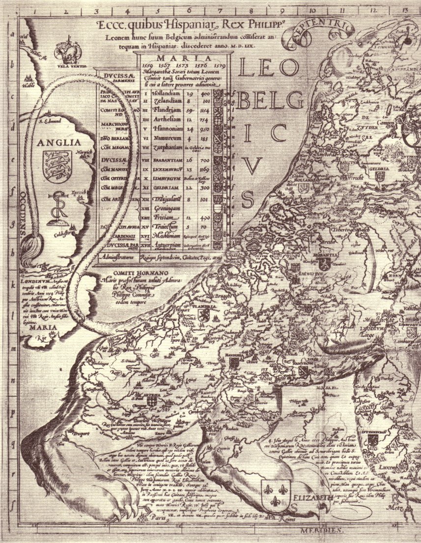
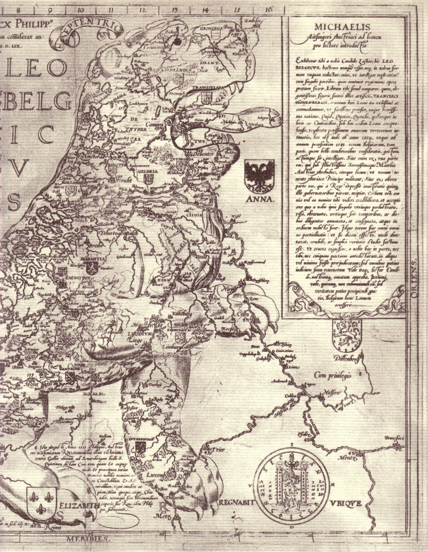
On the maps of the time, the selection of "provinces" may be slightly different. Below the West and East part of the Leo Belgicus map (1583) by Frans Hogenberg:


leow.jpg

leoe.jpg

Fot this map "Lille-Douai-Orchies" as well as "Tournai with the Tournaisis" are supposed to be included in Flanders. "Antwerp" and "Zutphen" are listed as "provinces" on the contrary.
"Transinsulana" stands for "Overijsel" and "Traiectum" stands for "Utrecht".


car.jpg  
The map above was scanned from a reproduction p. 173 in:
Charles Terinden, "Carolvs Qvintvs, Keizer Karel de Vijfde", Brugge, Desclée De Brouwer, 1965, 269 pp + loose leaf pictures.


Map makers clearly had problems with namegiving of this unity of "17 Provinces".

    heijden.jpg
An overview of names for the Low Countries on early maps, selected from the inventory made by H.A.M. van der Heijden, "Old maps of the Netherlands 1548-1794", an annotated and illustrated cartobibliography, 1998, Leuven, Universitaire Pers, vol. I, 1548-1672, ISBN 90-6186-909-9, VI + 484 pp., Vol II, 1672-1794, II pp + pp 485-892 (maps covering the actual Benelux plus Nord-Pas-de-Calais in France as a whole):

1557 Hieronymus Cock: French ".. pays bas ..."; Latin : "... Germaniae Inferioris..."; Dutch: "... nederlanden..."
1560-65 Paolo Forlani: Italian "... Gallia Belgica...."
before 1567 anonymous: Italian: "... Belgica..."
before Oct. 1568 Matthias Zündt: Latin: "... Belgicam..."
1568/73 Christiaan s'Grooten: Latin: "... Germaniae inferioris..."
1570 Abraham Ortelius: Latin: "... Germaniae inferioris.."
1575/79 Frans Hogenberg: Latin "Belgium", Italian "Il Paese Basso", Dutch "Niderlandt", French "Le Pays Bas"
1577 Philips Galle, Latin "... Germaniae Inferi="
1578 Frans Hogenberg, Latin "Germaniae inferioris..."
1578 Gerard de Jode, Latin "Germaniae Inferioris / Galliae Belgicae...."
1578-1602 Philips Galle- Johan Baptist Vrients, Latin "... Belgi sive Inferioris Germaniae..."
1580 anonymous: German: "Belgica ist zwischen dem Rhein, Mosz, Seyne und dem Grossen Mer beschlossen....", ".. General Tafel des Gantzen Belgicae. Inhaltende das Niderlandt, samt seinen XVII Ländern...", published in "Niderlands Bescheibung ..." (1580) "Die Dritte Tafel / des Rheinstroms / in deren begriffen ist dsz Nider Teutschlandt".
1581 Abraham Ortelius: Latin: "... Germaniae Inferioris..."
1582 anonymous, Latin: "Belgii inferioris..."
1588 review of previous map, Spanish "... los Payses bajos... Alemania la baja...", published in "Descripcio de Luis Gvichardino Patricio Florentin de todos los Payeses bajos, que per otro nombre sellaman Alemania la baja"
1582/1587-1598 Frans Hogenberg, map listed as "... Belgica Provincia...", on the 1598 version of the map: "... Germaniae Inferioris.."
1583-1588 Frans Hogenberg, Latin: "... suum Belgicum administrandum... Leo Belgicvs... " (this map is reproduced above on this very webpage)
1584 Abraham Ortelius, Latin: "Belgii veteris typvs...", text and signatures on the verso include: Latin: "Belgium" (1584); French "La Gaule belgique" (1585); German: "Niederlandt" (1584)
1584 anonymus (Gedruckt ... Cöllen), in German "Niderländische Beschreibung in Hochteutsch ... auf den Belgischen Löwen der Siebenzehen Provintzen deß gantzen Niderlants ...", a later version "Polemographia Belgica. Das ist: Niederländische Kriegsbeschreibung..."
1585 Gerard Mercator, in Latin: "Belgii inferioris..."; also published in Duysburg (1586) in "Die XVII Niderländische Provincien..." with on the verso of some copies ".. Belgii Inferioris Tabula...". Later editions of the map have on the verso: in Latin "Belgium sive Germania Inferior" (1606, 1607,... 1630), in French "Le Pays bas ou Basse Allemagne" (1609), "Le Pays Bas ou Basse Allemagne" (1613), "Le Pays bas ou Basse Allemagne ou Germanie Inférieure" (1619, 1628)
ca 1587: Frans Hogenberg, in Latin "... Germaniae Inferioris"
.. (etc)


What happened to the 17 provinces afterwards:

The North separated at the end of the 16th century and constituted, formally since 1648, the "Republic" or the "United Provinces". (Also called "United Netherlands"). It contained 7 provinces: Gelderland, Holland, Zeeland, Utrecht, Friesland, Overijsel and Groningen, and 3 territories (Generaliteitslanden): Drenthe, Staats-Vlaanderen (the extreme North of the Flanders), Staats-Brabant (the North of Brabant). Additionally parts of the "Landen van Overmaze" were acquired. It formed the basis of the actual Netherlands.

The South became at first the "Spanish", later the "Austrian", Netherlands and formed the basis (with additionally Liège, Stavelot-Malmedy, Bouillon and smaller territories) of the actual Belgium and Luxemburg. In the 17th and 18th centuries significant territory was lost to France (Artois, parts of Flanders, Hainaut and Luxemburg).
The lost parts of Flanders and Hainaut, together with Artois, form the French  region "Nord-Pas-de-Calais". This area is often also called the "Pays-Bas français".


This page is created as illustration for our pages about the history of the territory of Belgium
Created 2003-09-28,  last review 2003-11-09, relocated to the Combell server on 2020-10-25
Some texts may be affected by copyrights and eventually need to be removed from this server in the future
© Roger Thijs, Euro-Support, Inc.